National Weather Service
(PLACERVILLE, CALIFORNIA) Sept 18, 2022 — National Weather Service Meteorologists are forecasting thunderstorms over the burn scar, which may lead to ash and debris flows.
Flash Flood Watch – Motherlode-West Slope Northern Sierra Nevada- from Blue Canyon to Jackson.
…FLASH FLOOD WATCH FOR THE MOSQUITO BURN SCAR IN EFFECT FROM TUESDAY AFTERNOON THROUGH TUESDAY EVENING…
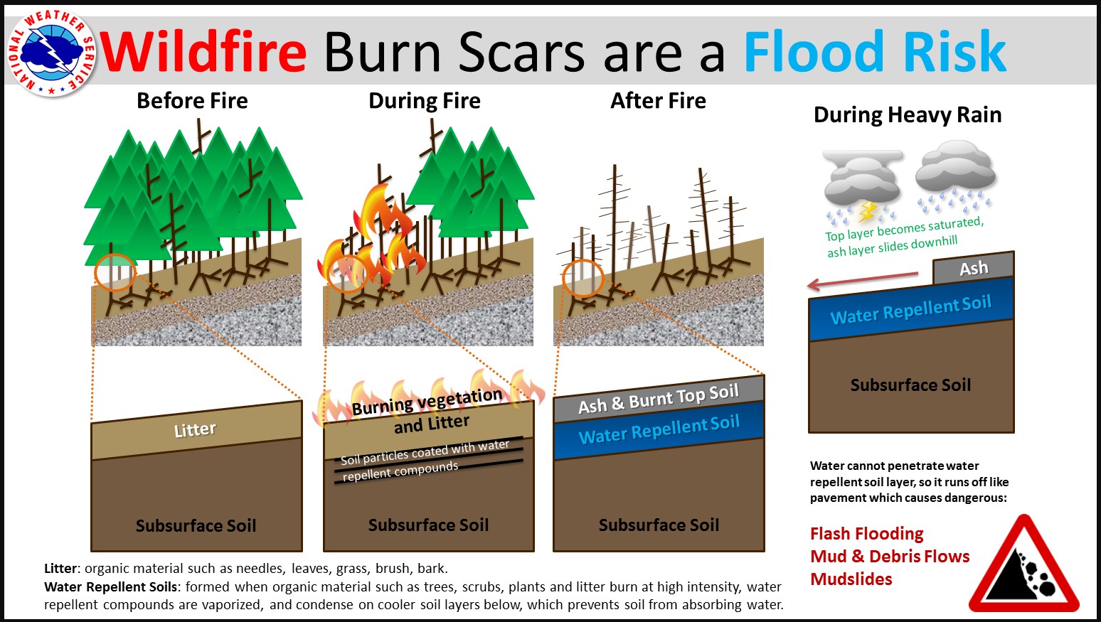
* WHAT…Ash and debris flows caused by thunderstorms are possible over the Mosquito burn scar.
* WHERE…A portion of northern California, including the following areas, Motherlode and West Slope Northern Sierra Nevada.
* WHEN…From Tuesday afternoon through Tuesday evening.
* IMPACTS…Thunderstorm threat with possible heavy rainfall over the Mosquito burn scar is expected during the period of the watch. Residents near the Mosquito burn scar should prepare for potential ash and debris flow impacts. Be sure to stay up to date with information from local authorities. Areas with steep terrain will be especially at a higher risk for ash and debris flows.
Area Forecast at 4,355 foot elevation [Foresthill]:
This Afternoon
A 30 percent chance of showers. Mostly cloudy, with a steady temperature around 61. South wind around 14 mph, with gusts as high as 21 mph. New precipitation amounts of less than a tenth of an inch possible.
Tonight
Showers likely and possibly a thunderstorm. Mostly cloudy, with a low around 53. South wind 5 to 9 mph becoming east southeast after midnight. Chance of precipitation is 70%. New rainfall amounts between a quarter and half of an inch possible.
Monday
Showers and possibly a thunderstorm before 9am, then showers between 9am and noon, then showers likely and possibly a thunderstorm after noon. Patchy fog before 11am. High near 63. East southeast wind around 6 mph becoming south in the afternoon. Chance of precipitation is 80%. New rainfall amounts between a quarter and half of an inch possible.
Monday Night
Showers likely and possibly a thunderstorm before midnight, then a chance of showers and thunderstorms after midnight. Mostly cloudy, with a low around 54. Light and variable wind becoming east around 5 mph. Chance of precipitation is 60%. New rainfall amounts between a quarter and half of an inch possible.
Tuesday
A chance of showers, then showers likely and possibly a thunderstorm after noon. Mostly cloudy, with a high near 63. Calm wind becoming southwest 5 to 7 mph in the afternoon. Chance of precipitation is 70%.
Tuesday Night
A 50 percent chance of showers and thunderstorms. Mostly cloudy, with a low around 52.
Wednesday
A 50 percent chance of showers and thunderstorms. Partly sunny, with a high near 63.
Wednesday Night
Mostly clear, with a low around 51.
Thursday
Sunny, with a high near 71.
Thursday Night
Clear, with a low around 57.
Friday
Sunny, with a high near 77.
Friday Night
Clear, with a low around 59.
Saturday
Sunny, with a high near 79.
Saturday Night
Clear, with a low around 61.
Sunday
Sunny, with a high near 81.
Area Forecast at 900 foot elevation [Diamond Springs]:
Tonight
Rain showers likely and a slight chance of thunderstorms. Lows 48 to 60. Prevailing southeast winds up to 15 mph.
Monday
Patchy fog in the morning. Rain showers and a slight chance of thunderstorms. Highs 60 to 70. Prevailing southeast winds up to 10 mph.
Monday Night
Mostly cloudy. Rain showers likely and a slight chance of thunderstorms in the evening, then a chance of rain showers and a slight chance of thunderstorms after midnight. Lows 49 to 61. Light winds.
Tuesday
Mostly cloudy. A chance of rain showers and a slight chance of thunderstorms in the morning, then rain showers likely and a slight chance of thunderstorms in the afternoon. Highs 62 to 72. Light winds becoming southwest up to 10 mph in the afternoon.
Tuesday Night
Mostly cloudy with a chance of rain showers and a slight chance of thunderstorms. Lows 48 to 58. Light winds.
Wednesday
Mostly cloudy with a chance of rain showers and a slight chance of thunderstorms. Highs 61 to 73.
Wednesday Night
Clear. Lows 47 to 57.
Thursday And Thursday Night
Clear. Highs 70 to 78. Lows 47 to 60.
Friday Through Sunday
Clear. Highs 75 to 88. Lows 52 to 65.