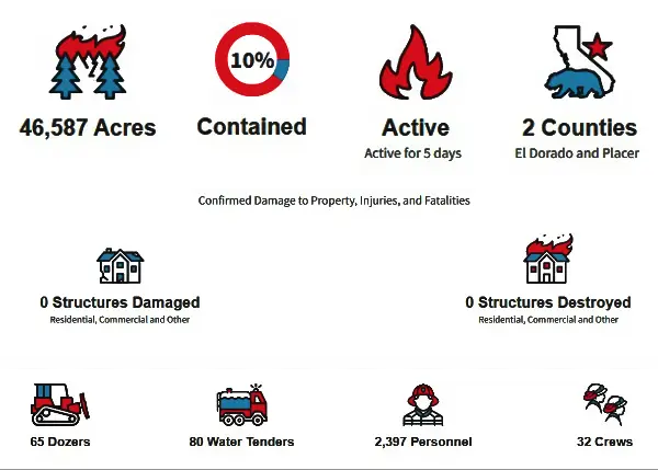
MOSQUITO FIRE INCIDENT UPDATE Date: 9-12
EldoradoNF
(PLACERVILLE, CALIFORNIA) Sept 12, 2022 —
| Last Updated | 09/12/22 8:12 AM |
|---|---|
| Date Started | 09/06/22 6:00 PM |
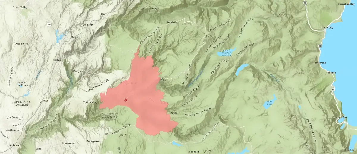
| Location Information | Mosquito Road and OxBow Reservoir east of Foresthill, Placer County |
| Lat/Long | [39.00591, -120.7447] |
| Administrative Unit | Unified Command: CAL FIRE Nevada-Yuba-Placer Unit, CAL FIRE Amador- El Dorado Unit, USFS Tahoe National Forest, El Dorado National Forest, Foresthill Fire Protection District, and El Dorado County and Placer County Sheriff’s Office |
| Command Team | CAIIMT Team 5 |
| Cause | Under Investigation |
| Reports | Click here for prior status reports |
Situation Summary
The Mosquito Fire continues to progress primarily to the north and east. Despite cooler temperatures, the historically dry fuel moisture in the vegetation continues driving the fire’s growth. On Sunday, the fire made a run to the northeast in the drainage between Foresthill Road and Deadwood Road. Firefighters have been building in-direct control lines and when necessary utilizing strategic firing operations to stay ahead of the fire on this corner.
Crews continue to look for opportunities to build in-direct control lines between the eastern front of the fire and Last Chance. The steep and rugged terrain make it difficult for ground crews to access the fire directly, therefore building control lines ahead of the approaching fire and building a buffer with defensive firing operations will allow firefighters the opportunity to slow and potentially stop the fire’s forward progress.
There was no significant growth on the southeast corner of the fire on Sunday, which gave crews more time to construct control lines coming out of Stumpy Meadows. Over the past few shifts, firefighters have been successful in securing containment lines on the southern edge along Volcano Road and to the north of Quintette. Crews continue to monitor these areas as well as strengthening the remaining control lines along this southern boundary to gain more containment. Firefighters continue to work towards hooking the southwest corner near Buckeye Point. Crews have successfully built a control line consisting of dozer and hand lines to the Middle Fork of the American River. This control line, in combination with firing operations, will help firefighters secure this piece of the fire perimeter. Locking in this southwest corner of the fire is today’s top priority for firefighters. Crews are also in the area of Todd Valley working to build contingency lines to further protect the community of Foresthill.
Today’s forecasted weather will be similar to that of yesterday, with a smoke inversion laying over the fire area in the morning and southwest winds clearing the smoke by early afternoon. These southwesterly winds, although not particularly strong, could push fire to the northeast in areas where the fire is in alignment with topography. With clearer air in the afternoon, fire activity is predicted to increase as it has in the past several days.
Full Fire Map 09/12/22 8:12 AM [Large File]

MoFi Fire Map
Detail – Volcanoville

MoFi Fire Map
Detail – Tunnel Hill

MoFi Fire Map
Detail – Quintette

MoFi Fire Map
Detail – Foresthill
