(InEDC) BY Claire McArthur / Special to the Tribune
08/5/23 7:47 PM PST
Technology is furthering innovation in wildland firefighting across the west, including the Tahoe Basin — and not just in the process of extinguishing flames but in prevention of these catastrophic burns.
Last fall, researchers at the University of Nevada, Reno, kicked off a series of projects that seek to map out the vegetation in the forests across California, especially the ladder fuels that carry low-intensity fires from the ground to the canopies of the trees. Crown fires are the most intense type of fire, difficult to contain and extremely dangerous for firefighting crews on the ground.


Named after the term for blazes reaching 1 million acres — a distinction most recently given to the Northern California-based August Complex in 2020 — the GigaFire Project is creating a statewide map that will help land managers identify where fire risk is the greatest and determine which of the fuel reduction methods will be most effective in a specific area.
“We are looking at where to find the wildlands fuel that contributes to catastrophic wildfires, how those fuels might change in the future under a variety of different management scenarios, and how the fuel management will specifically affect future carbon sequestration and water quality,” explains Jonathan Greenberg, co-principal investigator alongside Erin Hanan for the Department of Natural Resources and Environmental Science at UNR. “We’re using a variety of remote sensing and climate data, combined with models and machine learning, to project the current and future fuel conditions.”

Though mapping of tree density is not a new practice, a project of this scale — and one that is able to factor in the ladder fuels hidden beneath the canopy of trees — is invaluable for the future of firefighting.
“Ladder fuels are the part of a forest that people very poorly understand where the fuels are at scale,” notes Greenberg.
The researchers combine data from satellites already in orbit with aerial LiDAR (Light Detecting And Ranging), which can map the ladder fuels through the canopy, and ground-based laser scans. Computer modeling fills in the gaps.
“We combine what we can see with what we can’t see by using simulations based on our understanding of how fuels accumulate over time,” says Greenberg.
The analysis of all of this data at the scale of the entire state of California has required the aid of Google and ACCESS supercomputing centers.
“This is a big data problem,” explains Greenberg. “If you ran it on a single computer with a single processor it would take about 700 years to run all of the calculations.”
Forecasting of fires based on factors like fuel density and moisture, topography and weather is an important technological tool in CAL FIRE’s arsenal against wildfire.
“[The computer program] runs thousands of fires over the terrain in a given simulation and it gives an output of what all of those would look like combined into one scenario,” explains Brian Newman, Assistant Chief with CAL FIRE’s Amador-El Dorado Unit. “It gives us the ability to make good decisions based on where a fire is going, how fast it’s burning and make better decisions about where to put resources, what types of resources and what communities might be affected.”
It’s a resource that has evolved over the years from basic software to include real-time data.
“How long it would take to burn to specific area? What would the flame lengths be? How intense would it be? Would it lead to a crown fire or spotting? It really gives a good assessment of the potential of the fire,” adds Newman.
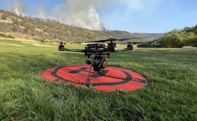
In 2021, CAL FIRE also standardized a drone program across its units. With an 8-foot span, the drones are flown over fires, day or night, and can collect thermal imaging, use LiDAR for 3D modeling, and regular video footage to assess the fire. The drones can also be used for aerial ignition for a controlled burn or to burn out fuel between the main encroaching fire and the control line.
A small chemical-filled sphere is injected with a reagent as it’s released by the drone, causing the sphere to catch fire as it nears the ground. It reduces the risk of people doing this from a helicopter or on the ground.

“The technology is pretty amazing. We can program into our drones a map of a given area to light a controlled burn and tell it we want the drone to fly at 100 feet off the ground and drop a ball every 4 seconds, stop at this location and go 50 feet laterally, and come back and do that back and forth,” explains Newman.
Another upgrade to CAL FIRE’s firefighting resources has been new aircrafts that work in conjunction with night vision goggles, allowing for water-dropping missions and rescue hoist missions of firefighting personnel to happen around the clock. This has allowed for CAL FIRE to dispatch planes on nights when there is critical fire weather — very windy during a dry period, for instance — and employ its aerial supervision model to pick up on any new fires.
The Amador-El Dorado Unit flew at night for the first time last July during the Electra Fire outside of Jackson.
“At night there are not as many people out, and we wouldn’t necessarily get a dispatch or a 911 call as quickly. This allows us to have much better situational awareness and a much quicker response time than we previously had,” says Newman.

Editor’s note: This article originally appeared in the Summer 2023 edition of Tahoe Magazine.


