
(InEDC) BY Adventures in California History
Published: 11:29 AM · Sep 1, 2023
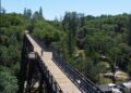
The original 1913 alignment of the Lincoln Highway followed old wagon roads, and this was the case here. The Lincoln Highway followed the Swan-Henry toll road, with the addition of two bridges, or “twin bridges,” that crossed the American River. The bridges were not side by side, but one went to an island while the other exited the island.
This photo is from c. 1913 and shows an auto crossing over one of the “Twin Bridges.”


Today Twin Bridges is a small unincorporated community on U.S. Route 50 near the Desolation Wilderness in El Dorado County, California. It is located 5 miles west of Echo Summit, at an elevation of 6,115 feet (1,864 m). It has a population of 14 people according to census figures, however, as of 2008, the road sign lists the population as 10.
Right after the town Westbound, the U.S. 50 eastbound starts a steep ascent to Echo Summit, passing Sierra-at-Tahoe [Sierra Ski Ranch] ski resort shortly before the summit.
Edelweiss ski area was located in US Hwy. 50 above Twin Bridges. It is near an area called Camp Sacramento. It had one chairlift.
Edelweiss closed in the early 60’s. It is now used as a snow-play area.
.

As you can see, it is mostly overgrown now. The old lift line is visible at the top of the hill.
When snow chains are required on the summit, Caltrans often establishes chain control in Twin Bridges. It is likely because of the limited availability of shoulders where chains can be installed on summit approaches.


![Grizzly Flat [ca. 1851-1852]](http://www.inedc.com/23/wp-content/uploads/2023/11/GrizzlyFlats-1851-1852-350x250.webp)
