Placerville Newswire
  • Crime
  • Culture
No Result
View All Result
Get Started
Placerville NewsWire
  • Crime
  • Culture
No Result
View All Result
Placerville NewsWire
No Result
View All Result

Flash Flood Risk Monday with New Heavy Rainfall Event

Cris Alarcon by Cris Alarcon
January 8, 2023
in Weather-Roads
451 5
0
Weather 1-8-2023
Share on FacebookShare on TwitterWhatsappReddit

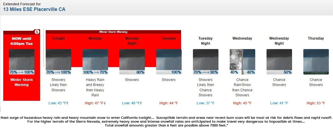
PLACERVILLE, California (NOAA) Jan 4, 2023 — Heavy snow expected at times. Accumulations of 3 to 6 feet, locally up to 8 feet, tonight through Tuesday above 6000 feet. South to Southwest winds gusting as high as 80 mph at times.

A barrage of atmospheric rivers continues to impact the West Coast with the next system set to sweep into California tonight.

You might also like

Fatal Crash Claims One Life in Pollock Pines

Fatal Crash Claims One Life in Pollock Pines

June 22, 2024
Hazardous Weather Conditions Alert: Heat Advisory for Motherlode

Hazardous Weather Conditions Alert: Heat Advisory for Motherlode

June 20, 2024

Heavy rain is expected to add up to several inches across much of central California through Tuesday. The cumulative effect of successive heavy rainfall events will lead to additional instances of flooding. This includes rapid water rises, mudslides, and the potential for major river flooding.

A Moderate Risk (level 3/4) of Excessive Rainfall has been issued for most of central California on Monday, extending southward towards the Transverse Ranges of southern California as well. As moisture continues to sink southward on Monday night and another push of rainfall enters on Tuesday, flash flooding is increasing likely over the southern California coastal ranges through early this week.

Susceptible terrain and areas near recent burn scars will be most at risk for debris flows and rapid runoff. For the higher terrain of the Sierra Nevada, extremely heavy snow and intense snowfall rates are anticipated to make travel very dangerous to impossible at times, including the potential for road closures.

Total snowfall amounts greater than 6 feet are possible above 7000 feet. This amount of additional accumulating snow on top of an already well built snowpack is likely to increase the threat of avalanches and strain infrastructure. Gusty winds are also expected to spread onshore with the approaching system and could lead to the threat of downed trees and power outages.

The combination of saturated soil and gusty winds could exacerbate the tree damage threat. Residents and visitors across this region are advised to check their local forecast, never drive across flooded roadways (Turn Around Don’t Drown!), and have both an emergency kit and evacuation plan in place. If you must travel, keep an extra flashlight, food, and water in your vehicle in case of an emergency.

The latest road conditions for the state you are calling from can
be obtained by calling 5 1 1.

Elsewhere, Pacific moisture that is able to push into the Intermountain West and central Rockies may lead to locally heavy snow on Monday and Tuesday throughout the higher elevations.

Graphics available at
https://www.wpc.ncep.noaa.gov/basicwx/basicwx_ndfd.php


Img – 38.67°N 120.56°W (Elev. 3589 ft) forecast.

Cris Alarcon

Cris Alarcon

Related Stories

Fatal Crash Claims One Life in Pollock Pines

Fatal Crash Claims One Life in Pollock Pines

by Cris Alarcon
June 22, 2024

Tragedy Strikes as Vehicle Accident Turns Fatal in California's Pollock Pines

Hazardous Weather Conditions Alert: Heat Advisory for Motherlode

Hazardous Weather Conditions Alert: Heat Advisory for Motherlode

by Cris Alarcon
June 20, 2024

Stay Hydrated: Drink plenty of water throughout the day. Seek Shade: Avoid direct sunlight during peak hours. Limit Strenuous Activities:...

Weekend Travel Alert for US-50: Mountain Snow and Rain Ahead

Weekend Travel Alert for US-50: Mountain Snow and Rain Ahead

by Cris Alarcon
December 27, 2023

Week wraps up with Snow over Summit

Prepare for Rain Showers

Motherlode Weather Forecast – Elev: 905.0 ft

by Cris Alarcon
December 26, 2023

Mostly cloudy gives way to rain showers

Recommended

Veterans

El Dorado County Unites in Gratitude: Veterans Day

November 10, 2023
Wine Grape Harvest Is Underway in the El Dorado AVA

Wine Grape Harvest Is Underway in the El Dorado AVA

September 15, 2023

Popular Story

  • VW Bus Halloween Pumpkin

    Spooktacular Halloween Events in El Dorado County 2023

    661 shares
    Share 264 Tweet 165
  • Tamara Wallace Elected to CALAFCO’s Board

    617 shares
    Share 247 Tweet 154
  • Hometown Hero Ed Hagen Leads Hangtown Christmas Parade Down Main Street

    701 shares
    Share 280 Tweet 175
  • Financing the Future: The Journey of Placerville’s Mackinaw Boutique Hotel

    704 shares
    Share 282 Tweet 176
  • El Dorado County Sheriff Arrests and Activity on June 22 2024

    704 shares
    Share 282 Tweet 176
  • Buy JNews
  • Support Forum
  • Pre-sale Question
  • Contact Us

© 2023 Placerville Newswire Commentary is produced by the Placerville Newswire, a private service focusing on Placerville Local Area issues. All conclusions expressed in this publication should be understood to be solely those of the author(s). You may find us in El Dorado County Placerville, CA 95667

Welcome Back!

Login to your account below

Forgotten Password? Sign Up

Create New Account!

Fill the forms below to register

All fields are required. Log In

Retrieve your password

Please enter your username or email address to reset your password.

Log In
No Result
View All Result
  • Landing Page
  • Buy JNews
  • Support Forum
  • Pre-sale Question
  • Contact Us

© 2023 Placerville Newswire Commentary is produced by the Placerville Newswire, a private service focusing on Placerville Local Area issues. All conclusions expressed in this publication should be understood to be solely those of the author(s). You may find us in El Dorado County Placerville, CA 95667